| Community Threat | Past Cyclone Details | ||||||||||||||||||||||||||||||
|
|
||||||||||||||||||||||||||||||
| Current Cyclone Details | Forecast Cyclone Details (at 24 and 48 hours from issue) |
||||||||||||||||||||||||||||||
|
|
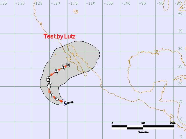
The forecast path shown above is Samoa's best estimate of the cyclone's future movement and intensity. There is always some uncertainty associated with tropical cyclone forecasting and the grey zone indicates the range of likely tracks.
Due to the uncertainty in the future movement, the indicated winds will almost certainly extend to regions outside the rings on this map. The extent of the warning & watch zones reflects this.
Name: [! No value and no default value for disturbance_type element !] Seimore
Details:
| Time (WSDT) | Intensity Category | Latitude (decimal deg.) |
Longitude (decimal deg.) |
Estimated Position Accuracy (km) |
|
|---|---|---|---|---|---|
| 0hr | 10 pm October 26 | 1 | 15.5N | 115.8W | [! No value and no default value for observed_uncertainty element !] |
| +6hr | 4 am October 27 | 1 | 15.9N | 116.9W | 30 |
| +12hr | 10 am October 27 | 1 | 16.4N | 117.9W | 55 |
| +18hr | 4 pm October 27 | 1 | 17.0N | 118.8W | 85 |
| +24hr | 10 pm October 27 | 1 | 17.6N | 119.5W | 110 |
| +36hr | 10 am October 28 | 1 | 19.0N | 120.2W | 170 |
| +48hr | 10 pm October 28 | 1 | 20.0N | 120.2W | 230 |
The next Forecast Track Map will be issued by 9:00 pm WSDT Wednesday